Limited windows on the weekend, slow next week
Southern Tasmania Surf Forecast by Craig Brokensha (issued Friday 20th July)
Best Days: Early Saturday, Sunday morning, early Wednesday, Thursday
Recap
Clean conditions and a drop in swell back to 2-3ft yesterday morning after kicking strongly Wednesday afternoon.
This morning the swell was hanging in at 2-3ft, but we should be seeing some new swell kicking this afternoon and an onshore change is holding off for now.
Today’s Forecaster Notes are brought to you by Rip Curl
This weekend and next week (Jul 21 - 27)
Want to receive an email when these Forecaster Notes are updated? Then log in here and update your preferences.
Our new pulse of W/SW groundswell and SW windswell due from the tail end of the frontal system linked to yesterday afternoon's and this morning's is still on track, but the SW windswell component has been downgraded.
This is due to today's delayed onshore change, and the delayed movement of the low across us.
Once it does so, it will be weaker, but in any case we should see fun 2-3ft surf tomorrow morning, easing through the day and smaller from 1-2ft Sunday.
 Conditions tomorrow are now looking a touch dicey with the delayed movement of the low. SW winds are expected most of the day, tending W/NW only for a period through the early-mid morning.
Sunday should be great though with N/NW tending N/NE winds.
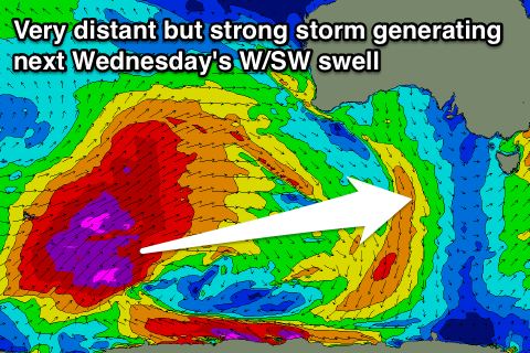
Moving into next week, and we've got tricky and inconsistent levels of W/SW groundswell on the cards, generated by distant and poorly aligned but significant storms between Heard Island and Western Australia.
The activity will occur too far west and too north of us to generate any significant swell at all, and even though the models are picking up some decent size, i'm sceptical if we'll see anything at all.
Tuesday looks like a tiny to flat day, with Wednesday looking the most likely to pick up very inconsistent 1-2ft sets.
Some small more inconsistent W/SW windswell may be in the mix Wednesday afternoon and Thursday from the remnants of the storm pushing across us.
This looks to only be 1-2ft, though we'll have another look at this Monday. Conditions Wednesday look best early with a W/NW offshore, tending W/SW mid-morning and better Thursday from the NW.
Have a great weekend!

