Large groundswell filling in tomorrow, easing Friday
Southern Tasmania Surf Forecast by Craig Brokensha (issued Wednesday 23rd May)
Best Days: Protected spots tomorrow, Friday, Saturday, Sunday morning
Recap
Bumpy 3-4ft waves yesterday morning, kicking larger into the afternoon opening up options in protected spots, with cleaner easing surf into today.
Today’s Forecaster Notes are brought to you by Rip Curl
This week and weekend (May 24 – 27)
 Today's easing trend is only temporary as we've got another large and powerful SW tending S/SW groundswell due tomorrow and Friday morning.
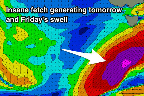
Currently the second of three vigorous polar lows is currently south-west of us, generating a fetch of severe-gale to storm-force W/SW winds (satellite confirmation right).
We'll see this system project up towards and into the Tasman Sea tomorrow, with a fetch of storm-force SW winds being drawn out from the polar shelf in our southern swell window.
This will create a large and powerful SW tending S/SW groundswell that should build to 5-6ft across Clifton through tomorrow, peaking into the afternoon and then easing overnight, dropping from 3-4f+ early Friday, smaller into the afternoon.
 There should be some fun S/SE swell in the mix Friday afternoon and Saturday from a fetch of S/SE gales on the backside of the low tomorrow afternoon.
This will likely keep 2ft to maybe 3ft sets into Saturday morning, easing through the day.
Winds tomorrow look W/NW early, but a shift to the W/SW is due through the morning, favouring protected locations.
Friday will then see a NW offshore, tending variable into the afternoon, similar Saturday.
The third and final low has fallen apart a little, with only a brief and small fetch of strong to gale-force W/SW winds being generated in our southern swell window Friday.
This will produce a small S/SW swell for Sunday morning to 2ft, easing through the day with N/NW tending N/NE winds.
Longer term we've got a mix of long-range and inconsistent swells due Tuesday onwards, mixed in with some closer-range swell, but more on this Friday.

