Large swell pulses with varying winds
Southern Tasmania Surf Forecast by Craig Brokensha (issued Monday 21st May)
Best Days: Protected spots tomorrow PM, early Wednesday morning, Thursday, Friday, Saturday, Sunday
Recap
Good clean 2-3ft waves Saturday with a reinforcing SW swell, while a stronger SW swell was seen Sunday to 3-4ft with early W'ly winds.
This morning the swell has dropped back to the 2-3ft+ range, but some new energy should be starting to show across the region as a vigorous front strengthens right under us.
Today’s Forecaster Notes are brought to you by Rip Curl
This weekend and next week (May 22 – 27)
As touched on the last few updates we've got a very active forecast period owing to a strong node of the Long Wave Trough stalling over the Tasman Sea.
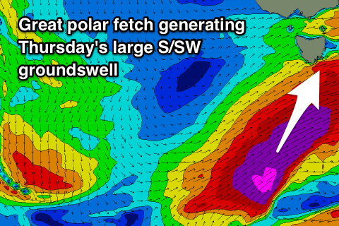
Currently a vigorous and strengthening polar front is generating an elongated fetch of gale to severe-gale W/SW winds through our south-western swell window.
This front will take a more north-east trajectory up into the Tasman Sea tomorrow morning while continuing to generate an amazing fetch in our swell window.
 A large SW tending S/SW groundswell should be generated by this system, building through tomorrow and peaking overnight before easing Wednesday.
We should see Clifton building from the 4ft range tomorrow morning, more to 5ft into the afternoon but with strong SW winds.
Wednesday will see easing 4-5ft surf out of the S/SW with better W/NW winds, holding until mid-afternoon when a W/SW change moves through.
This will be related to a vigorous polar low generating a fetch of severe-gale to storm-force W/SW tending SW winds through our swell window tomorrow evening and Wednesday.
With this another large long-period S/SW groundswell is due to fill in Thursday, providing solid 4-6ft waves across Clifton with an early W/NW offshore, swinging W/SW later morning.
The swell will drop quickly into Friday from 3-4ft with NW offshores, swinging more W/NW through the day.
A third and final pulse of long-period S/SW groundswell is due from another vigorous polar low firing up south-west of us Thursday. A fetch of severe-gale to storm-force W/sW tending SW winds should again generate a solid long-period S/SW groundswell for Saturday afternoon to 3-4ft across Clifton with a N/NW tending E/NE breeze, which isn't ideal.
The surf will then fade into Sunday, tiny into Monday before we see more zonal fronts generating W'ly swell from Tuesday onwards. More on this Wednesday.

