Plenty of swell to come, larger next week
Southern Tasmania Surf Forecast by Craig Brokensha (issued Friday 18th May)
Best Days: Saturday, Sunday afternoon, next week
Recap
Clean 2-3ft waves on offer yesterday morning ahead of a late and strong increase in long-period SW groundswell through the afternoon.
This morning the swell has dropped back quickly to the 3ft range with less than ideal conditions, but there should of still been a few bigger sets in the mix.
Today’s Forecaster Notes are brought to you by Rip Curl
This weekend and next week (May 19 – 25)
These notes will be brief as Ben’s away today.
Looking at tomorrow, and the new S/SW swell has been downgraded a little with the front passing under us today being weaker and angled more east to west.
This should keep 2ft sets hitting Clifton tomorrow though, with a stronger and more vigorous front passing under us into the evening, producing a bigger SW swell for Sunday.
 We're looking at good 3ft+ waves on Sunday, and winds over the weekend will vary.
An all day W/NW breeze is due tomorrow, with improving W/SW tending W/NW winds into Sunday afternoon as the front moves off to the east.
Sunday's swell should ease back into Monday, but another weak front pushing under the state through the day will keep 2-3ft surf hitting the region though with gusty W/SW winds.
From here we're expected to see a flurry of stronger frontal activity through our swell window, owing to a strong node of the Long Wave Trough stalling across the Tasman Sea to our east.
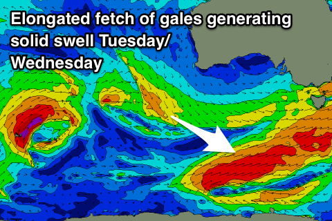
We'll see a flurry of strengthening polar activity aimed up towards us from Sunday through most of next week, with a significant storm likely to develop Wednesday.
The first system of consequence looks to generate a good SW groundswell for Tuesday afternoon and Wednesday morning to 3-5ft, with Thursday's swell looking to be more around 6ft with strong W/SW winds. We'll have a closer look at this Monday though. Have a great weekend!

