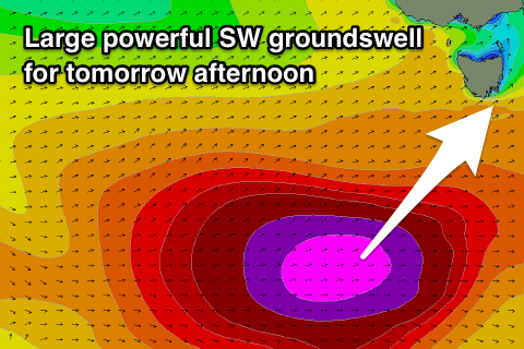
Large powerful SW groundswell tomorrow afternoon, plenty more swell to come
Southern Tasmania Surf Forecast by Craig Brokensha (issued Wednesday 16th May)
Best Days: Thursday afternoon, Friday morning, Saturday, Sunday
Recap
Average surf yesterday morning with less than ideal winds, though a strong new SW groundswell kicked later in the day, peaking this morning to a clean 3ft across Clifton.
Today’s Forecaster Notes are brought to you by Rip Curl
This weekend and next week (May 17 – 20)
These notes will be brief as Ben’s away today.
Today's swell should of eased into this afternoon and we'll start from a low base tomorrow, likely 2ft or so.
 Our large and powerful long-period SW groundswell for tomorrow afternoon is on track with satellite observations confirming a great fetch of storm-force W'ly winds being generated in our ideal swell window.
The severe low is currently projecting more east-northeast under us, towards New Zealand, with a rapid increase in size due through tomorrow, kicking to 6ft+ mid-late afternoon across Clifton.
A dawn W/NW breeze is now expected to give into a shallow S/SW change through the day, favouring protected spots as the swell spikes.
Friday morning should see an early W/NW offshore, tending W/SW mid-late morning with easing sets from 4-5ft.
Into Saturday a new pulse of S/SW groundswell is due, generated by a late strengthening low south of us on Friday.
A fetch of W/SW-SW gales should see a spike in size to 3ft+ into the afternoon with gusty W/NW-W winds.
From here on in we're looking at a prolonged period of SW and S/SW swell activity as a strong node of the Long Wave Trough across the Tasman Sea focusses strengthening polar storms up and across us.
More on this Friday though.

