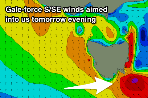
Large stormy S/SE swell for Friday, easing over the weekend with onshore winds
Southern Tasmania Surf Forecast by Craig Brokensha (issued Wednesday 9th May)
Best Days: Novelty breaks Friday, Monday
Recap
A strong kick in W/SW groundswell to 3ft yesterday from a very intense and strengthening low passing under us Monday evening.
This swell was expected to drop rapidly into today, but we've seen an even larger S/SW groundswell provide 3-4ft sets at dawn, dropping back quickly through the morning. Looking at the satellite observations and we can see that there was a secondary storm-force S/SW fetch wrapping around the underside of the low, and this was the source of today's swell.

Today’s Forecaster Notes are brought to you by Rip Curl
This weekend and next week (May 10 - 13)
We've got a good new W/SW groundswell due across the coast tomorrow, but this will be overshadowed by a local building stormy S/SE windswell as a deep and powerful low moves across us.
This W/SW groundswell that was expected to build to 2-3ft tomorrow afternoon will succumb to strengthening S/SE winds from mid-morning (variable from the W/NW early).
 We're expected to see winds reach 20-25kt+ into the afternoon and this will kick up a rapid increase in S/SE windswell to a junky 2-3ft.
Into tomorrow evening and winds will reach the gale-force range, aimed straight in to the south-east corner of the state, generating a large stormy S/SE swell for Friday.
We're looking at stormy waves in the 6ft+ range, in line with model guidance along with gale-force S/SE winds, easing through the day.
As these winds ease, so will the swell and into Saturday the low will push up the East Coast resulting in weaker easing surf from 3-4ft or so with fresh S'ly winds.
Come Sunday we're not looking at much leftover size and conditions will remain poor with a S/SW breeze.
Next week onwards (May 14 onwards)
Conditions will improve into Monday next week and a new new S/SW groundswell should be in the water, generated by a polar fetch of severe-gale W'ly winds Friday evening and Saturday.
2ft sets are due with all day offshore W/NW winds.
Into the middle of next week a strong front pushing up into us looks to bring an onshore increase in SW swell, but more on this Friday.

