Spike in W/SW swell tomorrow, stormy S/SE swell developing late week
Southern Tasmania Surf Forecast by Craig Brokensha (issued Monday 7th May)
Best Days: Tuesday, protected spots Friday/Saturday
Recap
A new sneaky swell Saturday to 2ft, while some expected swell on Sunday came in at 2ft through the morning, kicking a little later in the day, and holding 2ft+ this morning.
Today’s Forecaster Notes are brought to you by Rip Curl
This weekend and next week (May 8 - 13)
Today's swell should of eased into this afternoon and will continue to fade tomorrow, but we've got some an upgrade in the swell due tomorrow.
A deepening surface trough come low is forecast to generate a very short-lived but significant fetch of gale to severe-gale W/SW winds under us this evening.
 A quick spike in W/SW swell should be seen tomorrow morning to 2-3ft, dropping rapidly through the day.
Winds will improve through the day as the low pushes off to the east resulting in W/NW tending NW breezes, variable into the afternoon.
No swell is expected to be left into Wednesday with tiny clean conditions, but into afternoon a slight W/SW swell may be seen, more so Thursday though.
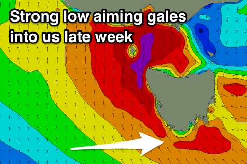
Thursday's swell is being generated by a strong low moving in from the Indian Ocean, aiming a fetch of W/SW gales just on the edge of our western swell window.
We'll see this storm continuing east over the coming days, before taking a turn north up into South Australia on Wednesday evening.
This will spawn a deep powerful low that will eventually make its impact on us later week, but firstly the W/SW swell for Thursday should build to 2-3ft through the afternoon.
Unfortunately the low as mentioned above will stall over Victoria and bring increasing S/SE winds creating poor conditions.
We'll then see gale-force S/SE winds aimed into the south of the state Friday and Saturday generating a large stormy S/SE swell for the same days.
The size of this swell depends on how long the low stalls across us and with what strength, so check back here Wednesday for more details.

