Tiny ahead of some new W/SW swell later Sunday/Monday
Southern Tasmania Surf Forecast by Craig Brokensha (issued Wednesday 2nd May)
Best Days: Exposed breaks Thursday, later Sunday, Monday
Recap
Fun easing waves from 2ft yesterday, back to a tiny 1ft this morning.
Today’s Forecaster Notes are brought to you by Rip Curl
This week and weekend (May 3 - 6)
The swell should hold around a tiny 1ft tomorrow, with a small weak low producing a mid-period W/SW swell through yesterday.
N/NE winds will favour more exposed breaks so it could be worth a check further afield.
 This swell will fade into Friday, while Saturday a strong mid-latitude low passing across us will generating a fleeting burst of strong W/SW winds under us early morning.
This may generate another tiny 1ft of W/SW swell with an increasing NW tending W/NW breeze.
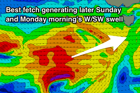
A flurry of stronger and elongated but unconsolidated polar frontal activity will move in from the west later this week and through the weekend, generating new pulses of W/SW swell for Sunday through Tuesday.
The best pulse for Sunday afternoon/Monday morning will be produced by the most consolidated fetch of gale to severe-gale W/SW winds and build to 2ft later in the day Sunday, with possibly the odd bigger one Monday morning.
Conditions will be good for these swells with an improving W/SW tending NW breeze Sunday and persistent NW winds all day Monday.
Some more distant and less consistent backup groundswell may be seen Tuesday, but with onshore winds in the wake of a trough. We'll have a closer look at this Friday.

