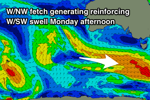
Easing W/SW swell tomorrow, with a new pulse late Sunday and more so Monday
Southern Tasmania Surf Forecast by Craig Brokensha (issued Friday 27th April)
Best Days: Saturday morning, late Sunday, Monday, Tuesday morning
Recap
Tiny surf yesterday, but today a new W/SW groundswell has come in at 2ft, with the odd bigger one at exposed breaks.
Today’s Forecaster Notes are brought to you by Rip Curl
This week and weekend (Apr 28 – May 4)
Today's W/SW groundswell should ease back from 1-2ft tomorrow morning with offshore winds lasting most of the day if not into the evening.
Sunday looks tiny, but later in the day and more so Monday we should see a new W/SW groundswell building across the region.
This swell has been generated the last couple of days by a vigorous polar low between West Oz and Heard Island.
 A great but distant fetch of severe-gale to storm-force W/SW winds were aimed through our western swell window and the low is now weakening well south of WA.
We should see a late pulse in size Sunday to 2ft across Clifton, peaking Monday to 2ft to occasionally 3ft.
Also in the mix will be some more consistent reinforcing W/SW energy Monday afternoon and Tuesday morning, produced by a broad but less than favourably aligned fetch of W/NW gales moving through our swell window over the weekend.
This will keep 2-3ft sets hitting the region into Monday afternoon before easing back from 2ft Tuesday morning.
Winds look as if they'll swing back W/NW later Sunday after swinging W/SW through the day, creating good conditions as the new swell kicks, with NW tending W/NW winds Monday.
Tuesday morning will be clean again, though the afternoon may be bumpy with weak easterly breezes.
Beyond this there's nothing significant on the cards until later next week/weekend when we may see a front pushing across us and turning into a deep low, generating a stormy S'ly swell. More on this Monday. Have a great weekend!

