Fun W/SW swells Friday and Monday
Southern Tasmania Surf Forecast by Craig Brokensha (issued Wednesday 25th April)
Best Days: Friday morning, Saturday morning, Monday morning, Tuesday morning
Recap
A slight pulse of S/SE groundswell yesterday but only to 1-1.5ft across Clifton, fading back through today leaving tiny surf on the coast.
Today’s Forecaster Notes are brought to you by Rip Curl
This weekend and next week (Apr 26 - 29)
From tomorrow afternoon we should see some fun swell action across the coast.
Firstly tomorrow will start tiny, but a weak mid-latitude front passing under us, generating a fetch of strong W/SW winds will kick up 1-2ft of swell late in the day, easing from a similar size Friday morning.
A new less consistent and long-range W/SW groundswell should override this easing W/SW swell though, produced earlier this week by a strong polar frontal progression between Heard Island and Western Australia.
We should see 2ft to possibly 3ft sets through Friday, easing later in the day and from a small 1-2ft on Saturday morning.
Winds later tomorrow will be average and gusty from the W, with Friday seeing better NW offshore, tending W/SW into the afternoon, and then morning N/NW winds Saturday ahead of a SW change.
 Sunday morning looks as if it will remain tiny and in the 1ft+ range, but later in the day and more so Monday a good long-period W/SW groundswell is due to fill in.
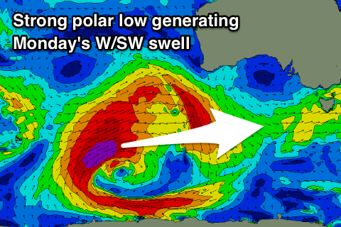
Currently a vigorous polar low is developing between Heard Island and WA, with a fetch of severe-gale to storm-force W/SW winds forecast to be aimed through our western swell window tomorrow, projecting slightly east while slowly weakening into Friday.
The swell off this system is now looking better for our region, with an increase to 2ft by dark expected Sunday, peaking Monday to 2ft to occasionally 3ft, though inconsistent.
Winds look good for Monday morning with a NW offshore, shifting W/NW through the day and likely W/SW at some stage.
The easing trend of the swell is likely to be buffered into Tuesday and Wednesday by less than favourably aligned by strong polar W/NW gales moving through our swell window Sunday and Monday.
Longer term our next swell looks to arrive Friday/Saturday but more on this Friday.

