Small S/SE swell tomorrow, with a new W/SW swell late week
Southern Tasmania Surf Forecast by Craig Brokensha (issued Monday 23rd April)
Best Days: Tuesday, Friday morning, Saturday morning, next Monday morning
Recap
Fun clean 2ft waves across the South Arm Saturday, holding into Sunday a little better than expected, back to a tiny 1ft today.
Later today we should see a new S/SE groundswell building across Clifton, kicking sets back to 2ft, but S/SE breezes are creating average conditions.
Today’s Forecaster Notes are brought to you by Rip Curl
This weekend and next week (Apr 24 - 27)
Later today's pulse of S/SE groundswell should hold into tomorrow, keeping 2ft sets hitting Clifton and then easing back through the afternoon. Winds are now looking a little less than ideal with a moderate to fresh N/NE morning breeze, tending lighter and more N/NW into the late afternoon/evening.
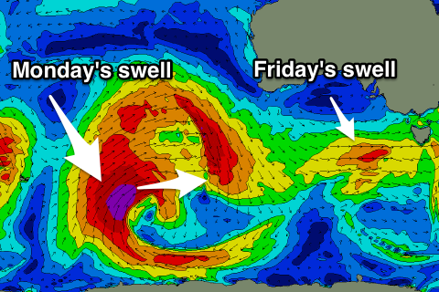
We'll then see tiny surf until Thursday afternoon, when two back to back fronts push under us, generating a late increase in W/SW swell, but more so Friday.
An initial weak front generating strong W'ly winds isn't likely to generate any size above 1ft+, but a stronger embedded low will slip under us through the day will be generating slightly stronger W/SW gales.
 This may kicked up 1-2ft of W/SW swell on dark Thursday but with gusty W'ly winds, but Friday should reveal better 2ft to sometimes 3ft sets as a better W/SW groundswell fills in, generated by the earlier stages of the front, as a polar storm today.
This swell will be less consistent but better and with a morning W/NW-NW breeze, tending SW mid-late morning.
After this unfortunately the swell will drop back through Saturday from 2ft on the sets but with N/NW offshores, ahead of SE sea breezes.
There's nothing significant thereafter besides an inconsistent and small W/SW groundswell for next Monday, generated by a strong and great polar low that will develop south-west of WA later this week.
A storm-force fetch will be on the edge of our western swell window, swinging more into our swell window in a weaker form as the system dips south-east towards the shelf.
We'll likely see fun surf in the 2ft range Monday with a morning offshore, fading into Tuesday.
Longer term the storm track will remain focussed away from our main swell windows, so try and make the most of the swells this week.

