Small S/SW swell Saturday and S/SE groundswell Tuesday
Southern Tasmania Surf Forecast by Craig Brokensha (issued Friday 20th April)
Best Days: Saturday morning, Tuesday morning
Recap
Smaller yesterday with easing sets from 2-3ft, fun today with a reinforcing S/SW swell to 2ft and light offshore winds.
Today’s Forecaster Notes are brought to you by Rip Curl
This weekend and next week (Apr 21- 27)
There isn't much expected in the way of surf over the coming period.
In the wake of the strong polar frontal progression linked to this week's large swells, weak S/SW winds on the polar shelf have generated a small S/SW swell for tomorrow, maintaining 2ft sets, before fading from 1-1.5ft on Sunday.
Conditions will be clean tomorrow morning with a N/NW offshore ahead of SE sea breezes and then NW tending SE winds Sunday.

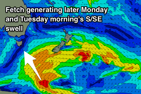
As talked about last update the only real swell due next week is a S/SE groundswell for later Monday and more so Tuesday morning.
This will be produced by a good fetch of S'ly gales projected north through our swell window tomorrow, well south of New Zealand.
We may see small 1-2ft sets later Monday but with SE winds, better Tuesday morning and around 2ft on the sets with a N/NW tending N/NE breeze.
Longer term we should see the Southern Ocean start to fire up again into the end of next week with a couple of strong polar fronts moving in from the west.
This will generate fresh W/SW swell energy from Thursday/Friday next week, but more on this Monday. Have a great weekend!

