Large swells over the coming days, with workable winds both days
Southern Tasmania Surf Forecast by Craig Brokensha (issued Monday 16th April)
Best Days:
Recap
Tiny waves Saturday with building surf Sunday coming in around 2ft through the morning, bigger later in the day.
Today we've seen a further increase in size to 3-4ft this morning, and a vigorous front passing under us should of boosted wave heights further this afternoon, but most of this swell has too much west in it.
Today’s Forecaster Notes are brought to you by Rip Curl
This weekend and next week (Apr 17- 22)
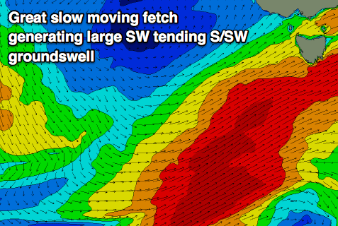
 At this point in time we've got a great fetch of SW gales extending from the south of our state, down to the polar shelf in our south-west swell window.
During this afternoon we're expected to see winds strengthen towards the severe-gale range and project a little more favourably through our southern swell window, persisting into tomorrow morning before shifting away from our swell window tomorrow evening.
What we'll see is a large SW groundswell developing through tomorrow, with a large reinforcing S/SW groundswell pulse late in the day, peaking overnight and easing Wednesday.
Clifton should see large 4-6ft surf most of tomorrow out of the SW, with possibly larger sets late in the day, easing back from a S/SW direction Wednesday from 4-6ft, smaller from 2ft to occasionally 3ft Thursday morning.
Winds tomorrow will be best for protected spots with a gusty SW tending W/SW breeze, with Wednesday looking cleaner at more exposed spots with a NW offshore ahead of weak sea breezes, similar Thursday as the swell fades.
Unfortunately from here there's nothing significant at all on the cards besides a small S/SW groundswell pulse for Saturday maybe to 1-1.5ft.
Therefore make the most of the coming large swell episode!

