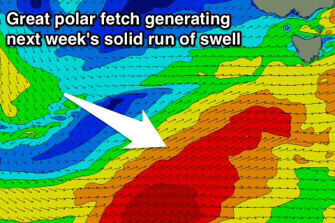
Prolonged run of swell from Sunday into next week
Southern Tasmania Surf Forecast by Craig Brokensha (issued Friday 13th April)
Best Days: Protected spots later Sunday, Monday morning, Tuesday, Wednesday morning
Recap
A kick in swell through yesterday but with poor winds for Clifton, cleaner this morning but tiny.
Today’s Forecaster Notes are brought to you by Rip Curl
This weekend and next week (Apr 14 - 20)
We're looking at tiny surf tomorrow, but into Sunday and more so the afternoon we should start to see some fresh W/SW swell building, the start of a prolonged swell event extending through most of next week.
A vigorous mid-latitude low is expected to push into SA tomorrow before dipping south-east and aiming a fetch of W/SW gales through our western swell window tomorrow afternoon and evening.
This should create a fun sized W/SW groundswell for later Sunday that's expected to reach 3ft, mixed in with local W/SW windswell energy from a fetch of strong W/SW winds pushing under the state Sunday.
 No real size is expected early, and a gusty W/NW wind will swing more W through the day, creating less than ideal conditions as the swell kicks later.
From Monday we'll see a constant stream of W/SW gales extending from us down through our south-western swell window to the polar shelf, with a fetch of stalling severe-gales Monday and Tuesday expected to generate strong levels of SW tending S/SW groundswell through Tuesday and Wednesday.
Size wise we're looking at Monday coming in around 3ft through the morning with a NW breeze, giving into a W/SW change and kick in size to 3-4ft into the afternoon, holding Tuesday ahead of the best pulse of swell Wednesday to 3-5ft.
Winds should hold from the W/NW most of Tuesday but Wednesday will see early W/NW winds, swinging SW as the frontal progression starts to shift more to the east.
We're then due to see the swell hanging in at a good size Thursday morning and strong SW gales in our southern window will continue to produce S/SW groundswell well into next weekend though with less than ideal winds. Early morning windows are likely, but we'll review this Monday. Have a great weekend!

