Small to tiny ahead of a large SW groundswell early next week
Southern Tasmania Surf Forecast by Craig Brokensha (issued Wednesday 11th April)
Best Days: Exposed locations Thursday, late Sunday, Monday morning, Tuesday, Wednesday morning
Recap
Tiny 1-1.5ft waves yesterday, back to the 1ft range this morning.
Today’s Forecaster Notes are brought to you by Rip Curl
This week and weekend (Apr 12 - 15)
We may see a small inconsistent increase in W/SW swell tomorrow to 1-2ft across Clifton, generated earlier in the week, but winds are poor and will only favour selected spots with a strengthening E/NE breeze.
The swell will then fade Friday with a NW offshore, tending NE into the afternoon.
 There's no new swell due until late Sunday when a flurry of strong mid-latitude fronts pushing across SA and Victoria dip further south and more into out swell window.
We'll see a small tight low project a fetch of strong to gale-force W/SW winds through our western swell window Saturday evening, followed by a front racing in and under us Sunday, with a possible late spike in swell to 2ft+ across Clifton along with gusty W/NW winds.
A much better fetch of W/SW gales under us Sunday evening should generate more size up to the 3ft+ range or so on Monday.
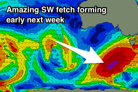
Of greater importance is a much stronger and better aligned fetch of gale to severe-gale SW winds projecting up and into us early next week, generating a large SW groundswell for Tuesday with W/SW winds.
We'll have to have a closer look at this on Friday.

