Small swell Thursday but onshore, better next week
Southern Tasmania Surf Forecast by Craig Brokensha (issued Monday 9th April)
Best Days: No great days until next week
Recap
Small surf on Saturday with clean conditions, while Sunday saw a kick in infrequent S/SE groundswell with long wait between fairly straight sets.
This morning the swell was on the way out and conditions were poor from dawn with a fresh onshore change.
Today’s Forecaster Notes are brought to you by Rip Curl
This week and weekend (Apr 10 - 15)
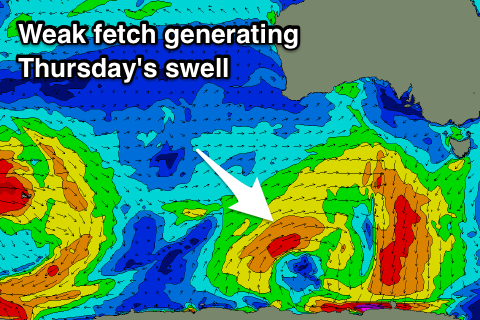
As touched on last week, there isn't too much on the cards for this coming week, with a bit of storm activity that's pushed up towards WA and is now drifting south-east through our swell window due to produce a small W/SW swell for Thursday.
 Only a small 1-2ft waves is expected but with poor and freshening E/SE winds as a surface trough deepens off our East Coast.
Better N/NE winds are due Friday as the swell fades from a tiny 1-1.5ft.
Into the weekend there's nothing of significance until Sunday as strong frontal activity in our far swell window and then mid-latitude fronts pushing into Vicco don't influence us until it drops south and moves across us Sunday.
Once it does though we're set to see a flurry of very strong and broad polar frontal activity, with fetches of severe-gale W/SW winds pushing through our western swell window under the influence of a strong node of the Long Wave Trough.
The models still diverge a little surrounding the timing and positioning of each front but we're looking at building W/SW swell later Sunday ahead of a stronger pulse Monday in the 3ft+ range. More on this Wednesday though.

