Very active period ahead
Southern Tasmania Surf Forecast by Craig Brokensha (issued Friday 30th March)
Best Days: Saturday, Sunday morning, every morning next week
Recap
Tiny waves yesterday, while today some new inconsistent W/SW groundswell has filled in providing 1-2ft sets across Clifton. A touch more size should have been seen through the day but our best pulse is due tomorrow.
Today’s Forecaster Notes are brought to you by Rip Curl
This week and weekend (Mar 31 – Apr 6)
Today's swell was generated by a less than ideal fetch of W/SW winds in our western swell window, but a better fetch of W/SW gales around a stalling polar low to our south-west yesterday and today has generated a better SW pulse for tomorrow.
We should see more consistent sets up in that 3ft range tomorrow, easing slowly through the afternoon, with easing 1-2ft waves on Sunday.
 Conditions tomorrow will be great most of tomorrow with an offshore N/NW breeze due to persist until mid-late afternoon ahead of sea breezes.
Sunday will also be clean into the early afternoon ahead of a shallow change.
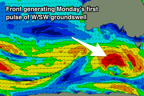
Late in the day Sunday we may see a new W/SW swell starting to show, but this swell for Monday and a secondary pulse Tuesday has been upgraded in size.
A couple of strong mid-latitude fronts are due to race through our western swell window today and over the weekend.
The first forming under WA will project a fetch of gale to severe-gale W'ly winds through our western swell window, generating a strong W/SW groundswell for Monday which should is expected to come in at 2-3ft through the morning, while a secondary front moving through Monday looks to keep wave heights up into the afternoon and and Tuesday morning.
A third front should generate a third pulse of slightly larger swell for Tuesday afternoon followed by a possible fourth polar low. More on this Monday though.
Winds next week will swing from W/NW to W/SW with each passing front but be favourable and offshore most mornings. Have a great weekend!

