Good clean S/SW swell tomorrow, with fun W/SW energy late week
Southern Tasmania Surf Forecast by Craig Brokensha (issued Monday 26th March)
Best Days: Tuesday morning, Friday morning, Saturday
Recap
Small clean fading surf on Saturday, tiny yesterday and into today.
We're currently seeing a strong mid-latitude low pushing across us and with this we've seen a gusty SW change. This will kick up some windswell later, though with no real quality.
Today’s Forecaster Notes are brought to you by Rip Curl
This week and weekend (Mar 27 – Apr 1)
The strong mid-latitude currently pushing across us is aiming a fetch of strong to near gale-force S/SW winds into the state and this will produce a late increase in S/SW windswell today, peaking overnight and easing quickly tomorrow from 2-3ft.
Winds are looking great with a morning NW offshore, tending W/NW and then onshore into the afternoon.
 We'll then see the coast go tiny ahead of some new W/SW groundswell later Thursday but more so Friday.
Currently a strong polar front is sitting in our far swell window, generating a fetch of W/SW gales, but this will weaken before undertaking a secondary intensification west-southwest of us mid-late week.
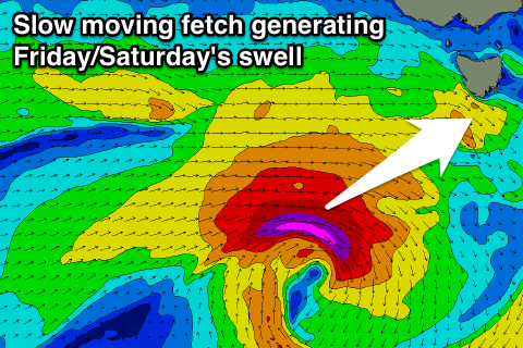
We'll see a slow moving fetch of gale to severe-gale W/SW winds in our western swell window producing a good W/SW groundswell for later Thursday but more so Friday, peaking into the late afternoon/evening and then easing Saturday.
Clifton should see 1-1.5ft sets later Thursday with all day offshore NW tending W/NW winds, while Friday is expected to build from 2ft, to 2-3ft later in the day, easing from a similar size Saturday morning.
Conditions should be clean Friday morning but later in the day looks bumpy with a W/SW breeze, while Saturday will be clean all day.
Longer term the outlook remains active as a series of fronts push through our western swell window, producing fun swell pulses next week.

