More action this week but with generally average winds
Southern Tasmania Surf Forecast by Craig Brokensha (issued Monday 29th January)
Best Days: Early Thursday morning, early Saturday morning
Recap
Tiny waves only for beginners over the weekend, flat into this morning.
Today’s Forecaster Notes are brought to you by Rip Curl
This weekend (Jan 30 – Feb 4)
We've got a little more swell on the cards for the coming week, but winds look to be the biggest problem.
Tomorrow, a tiny W/SW swell isn't expected to offer any size above 1ft and an onshore SW wind will create average conditions.
Moving into Wednesday and we'll see a relatively weak polar front pushing up and into us during the day, bringing an increase in S/SW windswell through the afternoon, reaching 1-2ft, and easing from a similar size Thursday morning.
 Unfortunately winds will be onshore as the front pushes up and across us, with a dawn W/NW'ly shifting S/SW shortly thereafter. We'll probably see a window of early W/NW winds Thursday morning as the swell drops from 1-2ft, shifting onshore mid-morning.
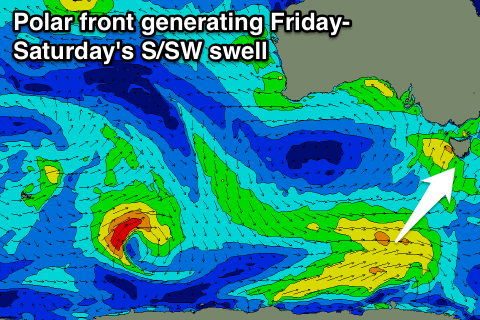
A secondary slightly stronger and better polar front is due to generate a better S/SW swell for Friday afternoon and Saturday morning, coming in at 2ft on the sets.
We may see a dawn W/NW'ly Friday morning before the swell really fills in, similar Saturday as the swell eases. We'll have a closer look at this Wednesday.
Another polar front pushing up past us during the weekend may generate some new S/SW swell for Sunday/Monday, but check back here Wednesday for more on this.

