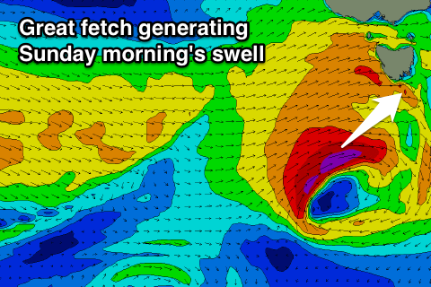
Fun swell Sunday morning, with smaller pulses early-mid next week
Southern Tasmania Surf Forecast by Craig Brokensha (issued Friday 29th December)
Best Days: Sunday, Monday morning, Tuesday morning
Recap
No swell yesterday and this morning with tiny clean surf.
Today’s Forecaster Notes are brought to you by Rip Curl
This weekend and next week (Dec 30 – Dec 5)
We've had a slight upgrade in the strength of the frontal system moving in and across us early tomorrow, bringing an increase in W/SW swell.
This front is currently south of the Bight, but will move east and strengthen slightly while dipping east-southeast.
We're now set to see a fetch of gale to severe-gale W/SW winds projected through our western and south-western swell windows, with the strongest part of the fetch occurring further south-west and away from us.
 What we should see is a late pulse of W/SW swell tomorrow to 2ft+ on dark across Clifton, but Sunday morning is looking better with the swell from the strongest part of the low filling in.
Sets to 2ft+ should continue, easing through the day.
Winds tomorrow will be poor when the swell kicks with a fresh W/NW tending strong W/SW breeze.
Sunday will be great all day with a NW tending W/NW breeze.
Monday morning looks tiny but into the afternoon and more so Tuesday morning some new W/SW swell is due.
Monday's increase looks very west in nature, generated by an unfavourable fetch of pre-frontal W/NW winds, but a trailing fetch of W/SW winds more in our south-western swell window should produce a better pulse Tuesday morning.
An increase to 1-1.5ft is expected Monday, while Tuesday morning should reveal better 2ft sets, easing through the day.
Winds look favourable and offshore from the W/NW each morning, W/SW into the afternoons.
A small reinforcing swell may be seen Wednesday, but more on this Monday. Have a great New Year!

