Average westerly swells with less than ideal winds
Southern Tasmania Surf Forecast by Craig Brokensha (issued Wednesday 27th December)
Best Days: Sunday morning, early Monday morning
Recap
Tiny leftover surf this morning with average winds.
Today’s Forecaster Notes are brought to you by Rip Curl
This week and weekend (Dec 29 - 31)
The surf is expected to remain tiny into the end of the week , but as we move into Saturday we're still set to see a strong mid-latitude front moving across us.
We'll see a burst of strong to near gale-force W/SW winds produced through our western swell window, with a late increase in acute W/SW swell due to 2ft by dark across Clifton Saturday.
Winds will unfortunately swing onshore and strong from the W/SW, creating poor conditions.
 Sunday morning looks smaller with fading 1-1.5ft sets under an all day offshore NW breeze.
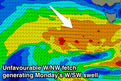
A secondary front moving in through Sunday and Monday looks to be a little less favourable than mentioned on Monday. The fetch associated with this front looks to be W/NW and and with this, the swell acute from the W.
We may see inconsistent 1-2ft sets at magnets, but i'd be expecting surf more to 1-1.5ft.
A trailing fetch of better aligned W/SW-SW winds should produce some better SW swell for Tuesday morning to 1-2ft.
Unfortunately winds will take a turn for the worse on Tuesday in the wake of the front with onshore SW breezes, lighter and more variable Wednesday with leftover sets. We'll have another look at this Friday.

