Strong swell for tomorrow and Friday afternoon, easing into the weekend
Southern Tasmania Surf Forecast by Craig Brokensha (issued Wednesday 20th December)
Best Days: Thursday, Friday, Saturday, early Sunday and Monday
Recap
Tiny leftover surf yesterday, effectively flat this morning, but later today we should see a building W/SW swell though with gusty W/NW winds.
Today’s Forecaster Notes are brought to you by Rip Curl
This weekend and next week (Dec 21 - 24)
We're currently seeing a severe low pushing in from the west, with its northern flank glancing the state.
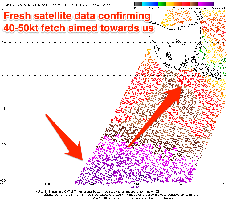
 This low has been upgraded in intensity since Monday and we're now seeing a fetch of severe-gale to storm-force W/SW winds being generated through our western swell window.
This will generate a good moderate sized W/SW groundswell for tomorrow morning to 3ft across Clifton, following a late increase in size today to 2ft+.
Larger surf will be seen at more exposed breaks and conditions are looking great with a N/NW tending W/NW breeze as the swell eases.
A temporary low point in swell is expected Friday morning ahead of our reinforcing W/SW swell for the afternoon. This swell is being generated by a secondary polar front that's formed south of WA. A fetch of gale to severe-gale W/SW winds will be projected towards us, passing under the state Thursday evening.
A good pulse of W/SW groundswell should be seen, building strongly Friday afternoon and reaching 3ft on the sets again across Clifton with a NW tending variable wind, possibly W/NW late again.
The swell should ease through Saturday from 2ft to possibly 3ft early as offshore NW winds persist ahead of a late change.
This change will be linked to a final weaker polar frontal system moving through, generating a small reinforcing W/SW swell Monday to 2ft.
Morning W/NW winds will create clean conditions both Sunday and Monday before shifting onshore mid-late morning.

