Small fun waves for the weekend, better swell later next week
Southern Tasmania Surf Forecast by Craig Brokensha (issued Friday 15th December)
Best Days: Saturday and Sunday mornings, Thursday next week
Recap
Tiny waves yesterday and this morning, but some new swell should be showing across Clifton now, with the Cape Sorell buoy rising nicely. Unfortunately sea breezes have just kicked in.
Today’s Forecaster Notes are brought to you by Rip Curl
This weekend and next week (Dec 16 - 22)
This afternoon's pulse of W/SW swell should reach 2ft across Clifton, dropping back to a smaller 1-2ft tomorrow morning.
A reinforcing W/SW swell is due into the afternoon, produced by a fetch of pre-frontal W/NW winds moving in under the Bight today. This should keep Clifton up around 1-2ft, while a weaker but better aligned polar front pushing east today and tomorrow will generate the third pulse of W/SW swell for Sunday morning.
 Only 1-2ft sets are due again before easing into the afternoon, tiny and 1ft+ Monday.
Conditions will be clean tomorrow morning with a NW offshore, giving into a shallow change through the afternoon, clean again Sunday morning ahead of SE sea breezes.
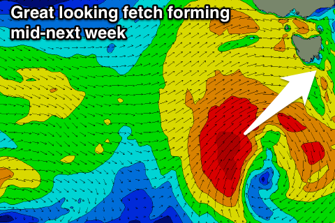
The surf will bottom out through Tuesday and Wednesday, but later in the week we'll see a strong polar frontal progression forming right off our doorstep.
This development will spawn from the interaction between a deep mid-latitude low off the WA coast and inland surface trough as they dip south-east together into the Southern Ocean.
It's hard to nail down the specifics at this stage but we're looking at a good fetch of gale to severe-gale SW winds forming in our swell window through Tuesday/Wednesday, generating a moderate sized swell for Thursday with W/NW-W/SW winds, but we'll have a more accurate look at this Monday. Have a great weekend!

