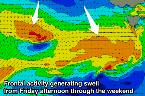
Small W/SW swells from Friday afternoon through the weekend
Southern Tasmania Surf Forecast by Craig Brokensha (issued Wednesday 13th December)
Best Days: Saturday morning and early Sunday
Recap
Not much in the way of S/SW swell yesterday with clean tiny 1-1.5ft waves, similar this morning, but fading.
Today’s Forecaster Notes are brought to you by Rip Curl
This week and weekend (Dec 14 - 17)
Our current tiny swell is due to fade further tomorrow leaving 0.5-1ft sets, if that across Clifton.
A broad and elongated but relatively weak frontal system moving in from the west should produce a fetch of W/SW winds in our western swell window, weakening and dipping south-east as it moves under us tomorrow evening.
The front is looking a little weaker than forecast on Monday, with an increase in size likely to 2ft on the sets Friday afternoon, easing back a touch Saturday to 1-2ft.
 Weaker trailing energy should keep inconsistent 1-2ft sets hitting the coast Sunday morning ahead of an easing trend into the afternoon, further Monday.
Conditions on Friday afternoon are looking bumpy with a W/NW tending E/NE breeze, while Saturday morning should be clean ahead of a SW change, W/NW early Monday and then S/SE through the day.
There's nothing significant for the rest of the week until later Thursday and more so Friday.
This will be in the form of a strengthening polar low directly south-west of us, as a deep and powerful mid-latitude low off the WA coast drifts south-east and is absorbed into the westerly storm track. More on this Friday.

