Fun swells through the week
Southern Tasmania Surf Forecast by Craig Brokensha (issued Monday 11th December)
Best Days: Tuesday morning, early Wednesday, Saturday, Sunday morning
Recap
Tiny waves to start Saturday but a new swell kicked through the afternoon, peaking late as winds remained favourable from the W/NW. Sunday was clean and easing back from 2ft on the sets, under the expected 2-3ft.
Today a reinforcing swell has kept small 1-2ft sets hitting Clifton with a light morning offshore.
Today’s Forecaster Notes are brought to you by Rip Curl
This week and weekend (Dec 12 - 17)
Today's reinforcing W/SW swell is expected to ease into tomorrow, but our small S/SW pulse is still on track, though downgraded in size.
The tail end of the polar frontal progression generating the weekend's swell has produced a trailing fetch of W/SW gales, not as favourably in our swell window.
We should now see sets just hanging around 2ft tomorrow morning with an offshore wind ahead of SE sea breezes.
 The swell should fade into Wednesday from 1-2ft with a N/NW tending NE breeze.
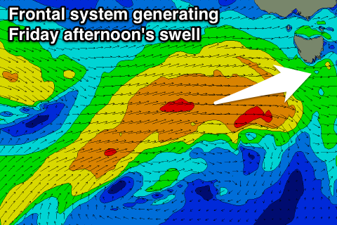
After the surf becomes tiny Thursday we're expected to see a strengthening frontal progression moving in from the west.
A slow moving fetch of strong to near gale-force W/SW winds will develop Wednesday afternoon through Thursday evening, producing a good W/SW swell for Friday, peaking late afternoon/evening to 2ft to nearly 3ft across Clifton.
Morning NW winds will favour Clifton though an E/NE breeze is likely into the afternoon.
A secondary pulse of W/SW swell is due into Saturday from a secondary fetch of W/SW winds forming on the tail of the initial front.
A similar pulse is expected into Saturday afternoon with N/NW tending W winds, easing back from 2ft Sunday under NW tending NE winds.
Longer term there's nothing significant on the cards, but we'll have another look at this Wednesday.

