Good Sunday, and fun early next week
Southern Tasmania Surf Forecast by Craig Brokensha (issued Friday 8th December)
Best Days: Sunday, Monday morning, Tuesday morning, Wednesday morning
Recap
Tiny waves yesterday and this morning, but we should be seeing a new SW swell building across Clifton, reaching 2ft and winds are due to swing back offshore from the W/NW with an approaching front.
Today’s Forecaster Notes are brought to you by Rip Curl
This weekend and next week (Dec 9 - 15)
The weekend's swell has been upgraded since Wednesday, with the strengthening front that's approaching from the west now on track to be similar to what was expected on Monday.
We'll see a broad and strengthening fetch of strong to near gale-force W/SW winds developing in our western swell window this afternoon and evening, pushing under us tomorrow morning.
 A moderate sized W/SW groundswell should be generated, building steadily through the day and peaking through the late afternoon/evening.
Clifton should reach an easy 3ft, though with a strong W/SW breeze, easing back from 2-3ft Sunday morning.
A secondary weaker and poorly aligned fetch of strong W/NW winds moving in Sunday will generate a reinforcing swell for Monday morning but only to 2ft or so, easing back through the afternoon.
Winds Sunday will be good all day with a fresh NW tending W/NW breeze and NW winds ahead of SE sea breezes Monday.
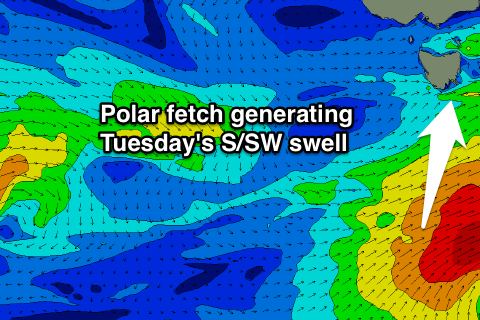
Into Tuesday we'll see some sneaky S/SW groundswell pushing into Clifton, generated on the tail of the strong front responsible for the weekend's swell.
A polar fetch of slow moving SW gales should produce a good 2-3ft S/SW pulse for Tuesday with offshore winds.
The swell is then expected to fade Monday under N/NE offshores.
Longer term we've got some small W/SW swell on the cards from late weekend, but more on this Monday. Have a great weekend!

