Solid SE swell developing over the weekend
Southern Tasmania Surf Forecast by Craig Brokensha (issued Friday 1st December)
Best Days: Protected spots Sunday and Monday, Tuesday morning
Recap
Tiny surf yesterday, flat today but a southerly change is now moving through along with heavy rain.
Today’s Forecaster Notes are brought to you by Rip Curl
This weekend and next week (Dec 2 - 8)
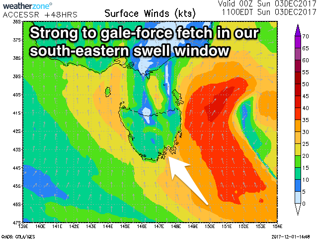
We've got a very dynamic and interesting forecast period ahead as the surface trough bringing today's change stalls just to our east and strengthens.
This will result in building levels of S/SE windswell through the weekend though with onshore S/SE winds.
 Through Sunday we'll see the trough deepend into a low, with gale-force S/SE winds generated within our south-eastern swell window, resulting in a larger stronger pulse of SE groundswell through Sunday afternoon and Monday morning.
Size wise, we should see Clifton coming in around 2-3ft or so tomorrow, building to a larger 4-5ft through Sunday afternoon, easing back from a similar size Monday morning.
Exposed breaks to the SE swell, especially Sunday and Monday will see much more size.
Winds will be poor though with strong S/SE winds tomorrow, S-S/SE Sunday and then more S/SW Monday morning.
We'll see the SE swell fade through Monday afternoon, smaller into Tuesday as winds likely improve, swinging NE, though we'll have to confirm this Monday.

