Poor week, potential from the weekend
Southern Tasmania Surf Forecast by Craig Brokensha (issued Monday 27th November)
Best Days: Swell magnets Wednesday morning and early Thursday
Recap
Small to tiny surf on both Saturday and Sunday for desperate surfers, back to the tiny stuff this morning.
A new W/SW swell should be showing across the region this afternoon though with gusty S/SE winds.
Today’s Forecaster Notes are brought to you by Rip Curl
This week and weekend (Nov 28 – Dec 3)
This afternoon's increase in W/SW swell should reach 2ft, easing back temporarily to 1-2ft tomorrow across Clifton. This was generated by a distant polar low in our far swell window, south-west of WA late last week.
Unfortunately a surface trough that's brought today's onshore winds will linger into tomorrow morning and from the SE. We may see breezes tend more variable if we're lucky, but don't count on it.
 Our reinforcing W/SW swell for Wednesday is still on track, with a secondary frontal system moving in on the backside of the low, generating hopefully 1-2ft sets into Wednesday morning, easing later and more so into Thursday.
Winds will clock more offshore, with a N/NE tending NE breeze Wednesday (favouring more exposed breaks) and N/NW tending variable winds on the Thursday as the swell fades from 1ft+ or so.
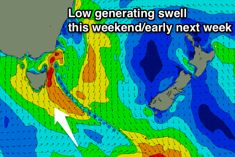
Longer term there's no significant groundswell on the cards for our region, but a deepening surface trough and low moving in late week is likely to bring some sizey but onshore S/SE windswell through Sunday/Monday.
The models are still moving around regarding the positioning of this system in our region, but we're likely to see swell building either Saturday or Sunday. More on this on Wednesday though.

