Tiny ahead of a new W/SW swell early-mid next week
Southern Tasmania Surf Forecast by Craig Brokensha (issued Friday 24th November)
Best Days: Wednesday morning
Recap
Our inconsistent W/SW groundswell came in on forecast with a slight lift in swell yesterday to 1-1.5ft with favourable winds for more exposed beaches.
Come this morning there was no real swell left with tiny glassy conditions.
Today’s Forecaster Notes are brought to you by Rip Curl
This weekend and next week (Nov 25 – Dec 1)
This coming weekend is poor with no decent swell at all besides a tiny S/SE windswell maybe to 1ft tomorrow, fading Sunday. Early tomorrow winds should be light offshore, while Sunday will see N/NE breezes, swinging NW ahead of a late change.
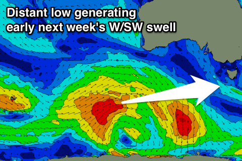
 Moving into early next week and our fun W/SW groundswell is still on track, with a strong polar low forming south-west of WA yesterday evening.
We're seeing a good but distant fetch of W/SW gales being generated in our western swell window, with an inconsistent and small W/SW groundswell due to build Monday afternoon, easing back into Tuesday.
Clifton should reach an inconsistent 2ft on the sets through the mid-late afternoon, dropping back to 1-2ft Tuesday. A secondary smaller front should generate a reinforcing W/SW swell for Wednesday morning, keeping 1-2ft sets hitting the coast before easing late in the day.
Winds will unfortunately be onshore as a surface trough moves in Monday, with S/SE breezes, while Tuesday is likely to see E/SE-SE winds. Wednesday will hopefully see a return to N/NE winds, but more on this Monday. Have a great weekend!

