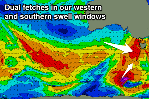
Lots of swell this period with varying winds
Southern Tasmania Surf Forecast by Craig Brokensha (issued Wednesday 27th September)
Best Days: Thursday afternoon, Friday, later Saturday, ealy Sunday, Monday morning
Recap
A small fun 1-2ft wave easing through yesterday but today our new S/SW groundswell has come in great with 2-3ft sets across the South Arm along with an offshore wind.
This week and weekend (Sep 28 – Oct 1)
Today's S/SW groundswell was generated by a strong polar front firing up through our southern swell window and should peak this afternoon before easing back from a similar 2ft to occasionally 3ft tomorrow morning.
Winds are looking a little dicey with a W/SW change due around 7am, with winds tending back W/NW into the afternoon.
Into Friday our W/SW swell is still on track with a relatively weak polar front expected to produced a broad fetch of strong and weakening W/SW winds towards us today and tomorrow before crossing us tomorrow evening.
 No major size is due with sets expected to reach 2ft through the morning with a N/NW tending NW breeze.
Moving into the weekend we'll see the stronger and larger W/SW groundswell filling in across the state, generated by a strong polar low firing up on the back of the weak polar front.
This low isn't expected to be as strong as forecast on Monday but we'll still see a great fetch of gale to severe-gale W/SW winds projected through our western swell window tomorrow and Friday, with a secondary slightly stronger fetch of SW winds stalling in our southern swell window on the polar shelf Friday evening.
What we'll see is a moderate sized W/SW groundswell for Saturday to 3-4ft, possibly a little undersized early.
A reinforcing SW swell is due from the polar fetch Sunday keeping 3-4ft sets hitting the coast most of the day, easing back from 3ft Monday morning.
We've got plenty of reinforcing W/SW energy due into early next week, produced by a great elongated fetch of W/NW gales moving slowly east through our western swell window over the weekend.
The swell will be long-lived, arriving Monday afternoon, holding through Tuesday and easing Wednesday.
Clifton should hang in at 2-3ft Tuesday, easing slowly Wednesday, but we'll review this Friday.
Coming back to the local winds and Saturday is still a bit average with gusty W/SW winds due through the morning, possibly swinging W/NW late in the day, persisting early Sunday before shifting W/SW again. Monday looks to follow a similar pattern.

