Good S'ly swell for the weekend, fun W/SW swell Tuesday
Southern Tasmania Surf Forecast by Craig Brokensha (issued Friday 8th September)
Best Days: Protected spots tomorrow, Sunday, Monday for beginners, Tuesday morning, Wednesday morning
Recap
A drop in swell from Wednesday, back to a clean 3ft or so yesterday morning before winds swung onshore mid-afternoon.
This onshore change was linked to a strong polar front pushing up and into us, bringing some solid new SW swell today to 3-5ft with offshore winds.
This weekend and next week (Sep 9 - 15)
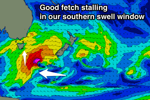
The strong polar front linked to today's solid increase in swell has stalled just south-southeast of us, with a tight embedded low forming in a broad fetch of S/SW gales.
This low will generate a tight fetch of severe-gale to storm-force S/SW winds this morning which now looks to be just east of our ideal swell window.
Still, with a broad fetch of strong to gale-force S/SW winds being aimed through our southern swell window today, we should see a moderate sized S'ly groundswell for tomorrow, coming in around 3-5ft across Clifton tomorrow morning, easing very slightly into the afternoon then down further from 2-3ft Sunday morning.
 Looking at the winds tomorrow and we're likely to see an early and short-lived W'ly tomorrow morning, swinging W/SW mid-morning and remaining onshore all day. Sunday will then be clean with a W/NW tending variable breeze.
Monday looks tiny but clean, while into Tuesday an inconsistent but fun W/SW groundswell is due.
This swell is being generated by a strong but distant polar low that's currently south-west of Western Australia, projecting a fetch of gale to severe-gale W/SW winds towards us. This low will weaken while tracking east tomorrow and Sunday, leaving a good W/SW groundswell to arrive later Monday, peaking Tuesday.
We should see easy 2ft sets across Clifton, with the likely hood of the odd bigger one. Conditions look clean through the morning but a trough moving across us is due to bring an onshore change through the day.
Wednesday will be clean again as the swell eases.
Longer term a good mid-latitude front will move in from south-west of WA, a little too north of our swell window, but slip more into it through next week. The front will pass across us Thursday when the swell is due, resulting in poor onshore conditions. More on this Monday though. Have a great weekend!

