Large back to back swells this week
Southern Tasmania Surf Forecast by Craig Brokensha (issued Monday 4th September)
Best Days: Protected spots over the coming days, Thursday morning, Friday protected spots, Saturday, Sunday morning
Recap
Tiny surf over the weekend with favourable winds for more exposed locations, even smaller into today.
This week and weekend (Sep 5 - 10)
A large, broad, cold and vigorous polar frontal progression is setup up to our west, directing W/NW winds across the state while also bringing snow to the mountains.
We've seen a great fetch of gales aimed through our western swell window and this has generated a moderate sized and initial W/SW groundswell for tomorrow morning in the 3ft range. A stronger pulse to 4ft is then due into the afternoon, generated by SW gales today.
 Into Wednesday though we'll see a large SW swell filling in, produced by an excellent polar fetch of gale to severe-gale S/SW winds being projected north-east through our south-western swell window.
Clifton should see large 6ft surf Wednesday morning, easing off slightly later in the day, down from 3-4ft Thursday morning.
Winds tomorrow look tricky with an early W/NW'ly due to swing strong W-W/SW from mid-morning.
Wednesday will then see similar morning W/NW breezes, shifting W/SW through the morning, back offshore from the NW Thursday morning ahead of a strong SW change late afternoon.
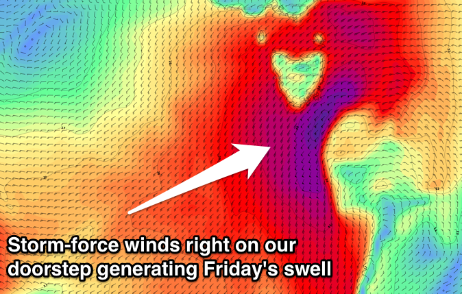
This change will be linked to a very strong and strengthening polar front pushing up and into us, generating a large S/SW groundswell for Friday.
Models have storm-force winds generated right off our coast, kicking up large messy surf in the 6ft range Friday morning along with strong SW winds. Protected spots will be the go.
The front will move off quickly to the east Friday and with this, the swell will drop rapidly, down from 3ft+ Saturday morning but with offshore winds.
Longer term we're looking at distant W/SW groundswell energy from the Indian Ocean, which isn't too exciting, therefore make the most of the coming week!

