Slow weekend, lots of swell next week
Southern Tasmania Surf Forecast by Craig Brokensha (issued Friday 1st September)
Best Days: Keen surfers Sunday afternoon, Tuesday, Wednesday, Thursday
Recap
Easing surf through yesterday but a little lumpy from Wednesday's onshores, cleaner but smaller and back to 1-2ft today.
This weekend and next week (Sep 2 - 8)
Tomorrow is expected to be tiny but clean, with great conditions for beginners. Sunday morning will start similar, but into the afternoon and inconsistent W/SW groundswell is due, generated by a distant polar frontal system earlier this week. Infrequent 1-2ft sets should be seen with N/NE tending W/NW winds with a change.
The swell is expected to ease back through Monday leaving fading 1-1.5ft waves with NW winds.
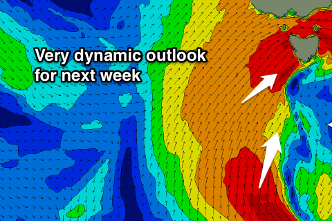
We then look to the complex outlook revolving around the strong and pronounced node of the Long Wave Trough stalling across the south-east of the country.
 A vigorous polar frontal system is currently positioned nicely in our far western swell window, south-west of WA. This system will project a good fetch of W/SW gales through our western swell window today and tomorrow before pushing north, just out of our swell window.
We should see a good sized W/SW groundswell from this system, filling in Tuesday and reaching a strong 3ft across Clifton.
The remnants of this front though is expected to move across us early Tuesday morning, aiming an additional fetch of severe-gale W/SW winds under the Tassie coast, generating an additional W/SW swell to the mix. At this stage we'll likely see sets pushing 3-4ft into the afternoon with gusty W/NW winds.
Of even more significance is an excellent polar fetch of gale to severe-gale S/SW winds developing in our southern swell window at the base of all this activity through Monday and Tuesday.
This will generate a moderate sized S/SW groundswell for Wednesday which is expected to build to the 4-5ft range as the W/SW swells eases from 3-4ft in the morning.
Winds are looking good for this swell with persistent W/NW breezes.
Beyond this the models diverge regarding a final strong cold-outbreak pushing up and over the state so check back here Monday for the latest on next week's developments. Have a great weekend!

