Easing clean surf, complex outlook next week
Southern Tasmania Surf Forecast by Craig Brokensha (issued Wednesday 30th August)
Best Days: Thursday, Friday morning, Sunday afternoon
Recap
Fun clean waves in the 2ft range yesterday, while today winds have swung onshore and we should be seeing more size building across the South Arm and reaching 3ft across Clifton, producing by a strong polar front pushing into us.
This week and weekend (Aug 31 – Sep 3)
The polar front responsible for today's change and building SW swell is clearing to the east and with this we'll see the swell drop through tomorrow from 2-3ft as winds swing back offshore.
A light NW breeze is due tomorrow morning, tending E/NE into the afternoon. Friday should still see 1-2ft sets through the morning with a fresh N/NW tending N/NE breeze.
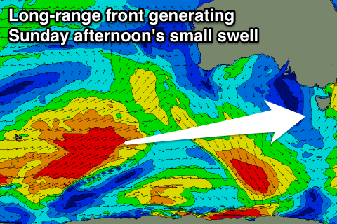
Into the weekend there's nothing major due, with tiny waves expected Saturday and a very inconsistent and small W/SW pulse for Sunday afternoon.
 This swell is being generated by a strong polar front that's currently east of Heard Island generating a fetch of broad W/SW gales in our far swell window. The front will project north out of our swell window tomorrow, with only inconsistent 1-2ft sets due into the afternoon but with offshore winds.
This swell will become tiny Monday and then things get interesting into the rest of next week.
A strong and pronounced node of the Long Wave Trough is forecast to move across the south-east corner of the country and stall early next week.
Now this is a little too west to be ideal for us, with the LWT needing to be further east and over the southern Tasman Sea to direct fronts up through our south-west swell window.
So initially we're looking at W/SW swell early next week with better swell potential late week, but more on this Friday.

