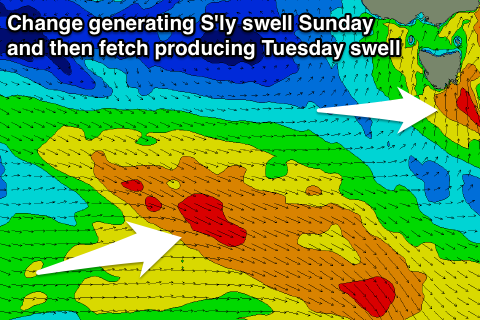
Great building swell tomorrow, onshore and poor Sunday
Southern Tasmania Surf Forecast by Craig Brokensha (issued Friday 25th August)
Best Days: Saturday, Monday, Tuesday, Thursday
Recap
Fun clean surf easing from the 2ft range yesterday, tiny into today with 1-1.5ft sets. Later today we should see some new W/SW swell reaching the 2ft range and conditions are remaining clean.
This weekend and next week (Aug 26 – Sep 1)
Later today's W/SW groundswell was generated by a good pre-frontal fetch of W/NW gales through our western swell window the last couple of days.
A much more significant trailing fetch of gale to severe-gale W/SW winds have been generating a larger SW groundswell for tomorrow, with sets due to build from 2-3ft early to a more significant 4ft into the afternoon.
This swell will ease from a similar size Sunday morning, but we're now due to see a trailing polar front pushing up and across the state.
 With this an additional S/SW windswell is due to fill in on Sunday, but this doesn't look to be above the size of the groundswell.
It will bring poor conditions though with a persistent NW breeze Saturday, giving into strong W/SW tending S'ly winds Sunday.
Into Monday we'll see the windswell and groundswell easing with fading 3ft sets across Clifton and offshore W/NW winds.
We should see a fun reinforcing SW groundswell for Tuesday, generated by a polar fetch of pre-frontal W/NW gales moving through our swell window.
This may be followed by another polar front pushing up and into us Wednesday, bringing more swell but we'll have to review this Monday.
Tuesday's swell looks to be in the 2ft+ range with offshore winds, but check back Monday. Have a great weekend!

