Tiny SE swell, average W swell, better S swell
Southern Tasmania Surf Forecast by Craig Brokensha (issued Wednesday 9th August)
Best Days: South-east facing breaks tomorrow afternoon, Sunday morning, Monday morning
Recap
Average S'ly swell yesterday with poor winds, easing back from a weak 1ft today with cleaner conditions.
This week and weekend (Aug 10 - 13)
The SE swell due across exposed south-east facing breaks tomorrow has been downgraded a little, with the fetch forming on the southern flank of a broad Tasman Low to our east, being a touch weaker than ideal.
We're likely to see inconsistent 1-1.5ft sets building across Clifton (bigger at more exposed breaks) and peaking through the afternoon before easing from 1ft Friday morning.
N'ly winds are due to swing more N/NW into the afternoon, favouring most spots open to the SE swell, with stronger W/NW winds Friday.
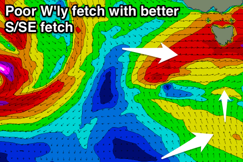
Moving into Saturday, and the frontal system due to generate an acute W'ly swell has been upgraded in strength a touch, but the fetch remains super west and tricky.
 We'll see gale to severe-gale W'ly winds projected east through our western swell window tomorrow, passing under us through tomorrow.
An acute W'ly swell is due off this storm, peaking Saturday morning with Clifton only likely to come in around 2ft before easing into Sunday from 1-2ft.
On the backside of a secondary front passing across us Saturday we'll see a much better aligned fetch of strong S/SE winds projected up through our southern swell window from below us.
This should produce a good S'ly swell for later Sunday and Monday morning. Sets to 2-3ft are due later Sunday, easing from a similar size Monday, tiny Tuesday.
Coming back to the expected conditions, and Saturday will see fresh to strong W'ly winds all day, holding early Sunday from the W/NW ahead of a S'ly change.
Monday morning should see NW offshores again, giving into a W/SW change through the day.
Longer term there's nothing significant on the cards as a slow moving mid-latitude storm moves in from the west, but more on this Friday.


Comments
Hey craig,
Hope you had a good weekend. I noticed that on the Vicco forecaster notes you mentioned a good new SW swell for late Sunday/Monday, and from what I can see at this stage the winds look good for some pretty tasty reefs SW .. is this swell going to hit South Arm ? I am meant to come back for work on Monday and not frothing on 1-2ft cliffy haha. Is there any reason for this discrepancy ?
Also, what's going on with WAMS ? It doesn't seem to be agreeing with what you're saying (from what I can see, I may be horribly wrong) and there is a stacked chart on the 25th of august which is hard to believe.
Sorry for all the questions, you should make this premium cus it's a good service and sorry if I'm abusing it !!
Cheers
Good spotting, SW swell for Vicco when I was doing their notes changed by the time I got to South Arm, and was was for you guys anyway. So at thus stage nothing special at all for early next week besides 2ft Cliffy.
actually that was a stupid way to quantify how good waves will be ... as a guestimate, how big do you reckon surfcoast will be ? obviously its a way out just wondering whether it's worth rebooking my flights back haha i'm stinging for some solid waves down south
actually nvm the size forecast, so in other words the hint towards a significant swell event for early next week for victoria isn't there anymore right ?
What about for victoria ? worth booking a $40 flight back for tuesday instead ?