Tiny S/SW swell tomorrow, much better swells Monday and Tuesday
Southern Tasmania Surf Forecast by Craig Brokensha (issued Friday 21st July)
Best Days: Saturday keen surfers, Monday, Tuesday, late week
Recap
Poor tiny waves across the region yesterday, while today conditions have cleaned up with a mix of swells to 2ft. The reports didn't sound great early but hopefully it's improved since.
This weekend and next week (Jul 22 - 28)
Today's mix of swells are due to fade overnight but we should see a small new S/SW groundswell offering 1-1.5ft sets tomorrow morning along with all day offshore N/NW winds.
Sunday should then go back to the tiny range with offshore winds ahead of a late afternon change.
This change will be linked to a weak trough moving across the state, with the earlier stages of the trough this evening and early tomorrow generating a broad fetch of strong S/SW winds towards us.
 A fun S/SW swell should result, peaking Monday morning to a fun 2ft across Clifton, if not for the odd sneaky bigger one through the day. Sunday's late change will move off to the east Monday resulting in offshore W/NW tending variable NW winds.
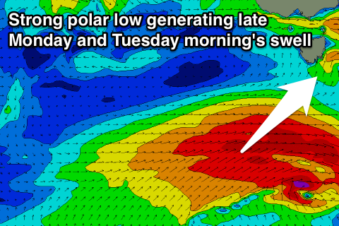
The stronger polar low forecast to develop Sunday is still on track, with a fetch of gale to severe-gale W/SW winds being projected through our south-western swell window.
This swell is expected to arrive late afternoon Monday, pulsing to a strong 3ft, and then easing from 3ft on the sets Tuesday morning.
The easing trend will be slow due a trailing polar front projecting strong SW winds through our southern swell window Tuesday next week, generating reinforcing SW energy.
Winds Tuesday look great with a fresh offshore ahead of a possible late change, that may linger into Wednesday.
Longer term we're looking at some fun S/SE groundswell mid-late week from a strong polar low stalling south of New Zealand, but more on this Monday. Have a great weekend!

