Make the most of Tuesday
Southern Tasmania Surf Forecast by Craig Brokensha (issued Monday 10th July)
Best Days: Tuesday, Wednesday morning, Friday keen surfers
Recap
Small waves Saturday to 1-2ft, but into Sunday a new W/SW groundswell filled in, pulsing to 2-3ft through the morning with offshore winds.
This morning the swell was back to 2ft, but we should see some new swell building into this afternoon and Cape Sorell is showing good signs with an increase in mid-period energy.
This weekend and next week (Jul 11 - 14)
The increase in swell due this afternoon and tomorrow morning was generated by a broad but relatively weak polar front projecting towards us over the weekend.
The swell is coming in from the W/SW this afternoon but we'll see the swell tend more SW into tomorrow due to the fetch on the back of the polar frontal progression generating the swell coming more from the SW (south of us today).
We should see Clifton coming in at 2ft to occasionally 3ft tomorrow morning, easing slightly through the day, down further from 1-2ft Wednesday.
Conditions tomorrow look great with a light offshore tending variable breeze, a little fresher Wednesday.
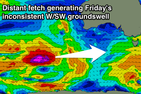
As talked about last update, we're due to see some new W/SW groundswell energy late week and into the weekend, but the positioning of the storm track isn't ideal for us at all.
 Currently a vigorous polar frontal progression is occurring between Heard Island and Western Australia.
The best and most southern positioned system is currently aiming a fetch of severe-gale to storm-force W'ly winds in our far western swell window.
This front will weaken into tomorrow, with a secondary broader front pushing north and out of our swell window.
With this, we can expect Friday's W/SW groundswell to offer more size than Saturday's, with very infrequent 1-2ft sets due across Clifton, tiny into the weekend.
Our models are incorrectly combining the two separate swells on Saturday and over-forecasting the size.
Conditions look clean Friday, but an onshore change is due Saturday and a stalling fetch of S/SW winds may generate some small S/SW swell for Sunday but we'll have a closer look at this in Wednesday's update.

