Great swells from the south
Southern Tasmania Surf Forecast by Craig Brokensha (issued Wednesday 17th May)
Best Days: Friday, Sunday afternoon, Monday
Recap
Good clean conditions with a new swell to 2ft yesterday, easing back only slightly to 1-2ft this morning.
This week and weekend (May 18 – 21)
We now look towards our good S/SW groundswell due later this week, with the polar frontal system generating this swell now a touch stronger than forecast Monday.
 Currently a vigorous polar front is generating a fetch of W/SW gales through our southern swell window, with it slowly pushing east through tomorrow.
What we'll see is a good S/SW groundswell generated by this progression, building strongly tomorrow afternoon to 3ft across Clifton by dark, peaking overnight and easing from 3ft Friday morning.
Winds will be offshore tomorrow morning, but onshore from the S/SE into the afternoon, while Friday is the pick with a light N/NW offshore, tending E/NE and then SE into the afternoon.
Come Saturday the swell will be on the way out and fresh NE winds will favour spots away from Clifton.
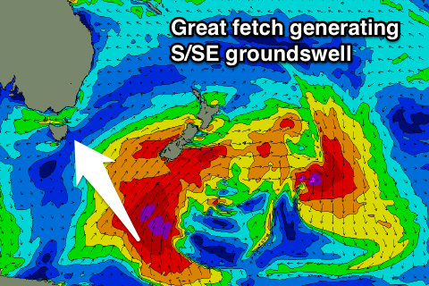
Our S/SE groundswell event flagged last update is still on the cards with the front generating our S/SW groundswell due to be absorbed into a much more significant polar storm south of New Zealand.
 We'll see a vast fetch of gale to severe-gale S'ly winds projected through our south-eastern swell window, producing a solid long-period S/SE groundswell.
This swell is forecast to arrive Sunday, building to a solid 3ft across Clifton into the afternoon, easing back from a similar size Monday morning. More exposed spots to the south-east direction should see bigger waves and light N'ly winds Sunday afternoon should create clean conditions, ideal from the NW tending N/NE Monday.
This swell will fade into Tuesday with nothing major on the cards for next week as the storm track remains too far north. More on this Friday.

