Easing SE swell with some fun SW swell for the weekend
Southern Tasmania Surf Forecast by Craig Brokensha (issued Monday 8th May)
Best Days: Saturday and Sunday mornings
Recap
Tiny clean waves Saturday with a flukey S/SE groundswell not really eventuating, while Sunday a stormy S'ly swell started to build, providing good options in protected locations late in the day.
Today the S'ly swell was on the ease, backing off from the 3ft range.
This week and weekend (May 9 – 14)
The stalling low responsible for yesterday's and today's S'ly swell is still sitting off our East Coast, but slowly weakening, and with this we'll see onshore SW winds persisting into tomorrow morning.
The swell is expected to smaller and easing out of the SE, back from a bumpy 1-2ft. Offshore winds are expected to kick in Wednesday but the surf will be tiny and only around 1ft max.
On Thursday our models are showing a long-period W/SW groundswell, but this swell was generated in the southern Indian Ocean too far north and west, out of our swell window. With this I wouldn't expect any real size at all over 1ft.
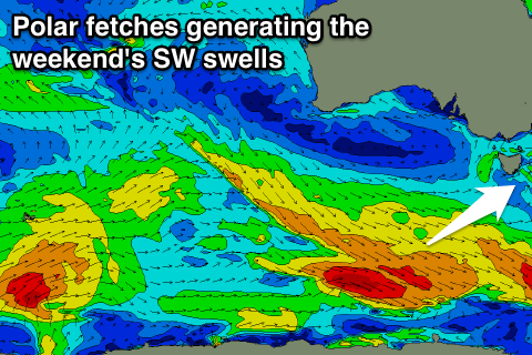
 Some better SW swell energy is due to build Friday afternoon and peak Saturday though, produced by a flurry of polar frontal activity mid-late week.
There won't be too much strength to each front, but with each system moving over the active sea state produced by the one before it, we should see some fun waves Saturday and Sunday.
2ft sets are due across Clifton with each pulse of SW swell, and morning NW breezes will create clean conditions.
Longer term we may see some slightly stronger polar frontal activity generating a bit more size early next week, but more on this Wednesday.

