Great day of waves Sunday, swell next week but onshore
Southern Tasmania Surf Forecast by Craig Brokensha (issued Friday 28th April)
Best Days: Sunday, Tuesday morning
Recap
Not the cleanest conditions to start yesterday with OK easing 2ft sets, improving through the day as persistent offshores ironed out the lumps and bumps.
This morning was clean again but only tiny.
This weekend and next week (Apr 29 – May 5)
Our mix of good swells for the weekend is still on track.
Currently a mid-latitude frontal progression is moving in from the west, with it having generated a healthy fetch of strong to gale-force W/SW winds through our western swell window.
The front will pass under us this evening, with a 2ft+ of W/SW swell due tomorrow morning across Clifton.
Through the afternoon some new long-period SW groundswell should reach 3ft, produced by a vigorous polar frontal progression earlier this week.
Winds are still looking average, with a slim chance of an early W'ly tomorrow morning, swinging W/SW mid-morning and SW into the afternoon.
 Sunday looks great with a NW tending variable breeze and easing mix of swells from 2-3ft, tiny Monday.
Into early next week a broad but patchy polar frontal progression will move in from the west.
We'll see mid-period onshore surf generated by this progression, with an initial change on Monday afternoon kicking up a W/SW swell for Tuesday but only to 2ft and with a morning W/NW offshore ahead of another change.
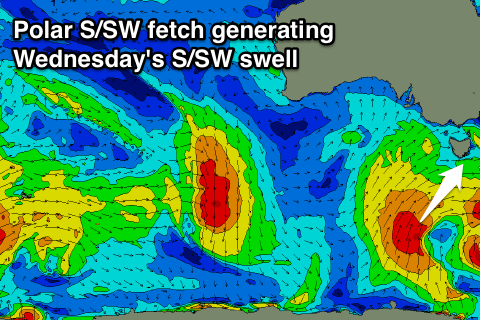
This secondary change will be associated with a better aligned polar front, projecting strong to gale-force S/SW winds up and towards us.
With this a new S/SW swell will be created for Wednesday, coming in at 3-4ft but with S/SW winds.
The swell may tend more S'ly into the end of the week but with less than ideal winds. More on this Monday though. Have a great weekend!

