Fun surf days Thursday and Sunday
Southern Tasmania Surf Forecast by Craig Brokensha (issued Wednesday 26th April)
Best Days: Thursday, Friday morning keen surfers, Sunday
Recap
Fun clean 2ft waves yesterday morning with the arrival of a new SW swell.
Today there was plenty of swell still on offer, but conditions were poor with a fresh and cold onshore wind.
This week and weekend (Apr 27 - 30)
This afternoon a mix of windswell and groundswell should be on the build, reaching 2-3ft across Clifton, but with this poor onshore wind.
Tomorrow morning should see a swing back to W/NW offshores, persisting into the afternoon as the swell eases back from 2-3ft early.
Come Friday smaller 1-2ft leftovers are expected with persistent NW tending W/NW winds.
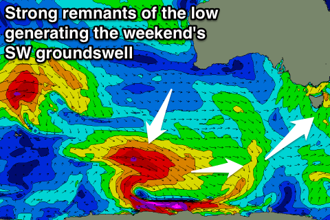
 Our long-period SW groundswell due over the weekend is still on track, with a vigorous low forming in the southern Indian Ocean projecting a fetch of severe-gale to storm-force W/NW winds towards the polar shelf, through our swell window.
This system will continue east through our swell window this evening and tomorrow morning, generating W/SW gales before weakening tomorrow afternoon.
The groundswell from this system should build Saturday afternoon, peaking through the evening and then easing Sunday.
Also in the mix will be a close-range W/SW swell from a mid-latitude front pushing in from the west, under us Friday.
This swell will be evident Saturday morning, coming in at 2ft, with the groundswell proper kicking to 3ft.
Both swells are then due to ease Sunday from 2-3ft, tiny Monday.
Winds on Saturday will unfortunately be poor with a W/SW tending S/SW breeze as Friday's front continues through, but Sunday looks excellent with all day NW offshores.
Next week we're looking at plenty of swell as a slow moving polar frontal progression moves in from the west. The only issue is that this progression will bring onshore winds which look to persist through the peak of the swell. More on this Friday.

