Good fun waves tomorrow, great swell Sunday
Southern Tasmania Surf Forecast by Craig Brokensha (issued Wednesday 12th April)
Best Days: Thursday, Saturday morning, Sunday, next week
Recap
Some new SW swell started to show through yesterday but conditions were average with onshore breezes.
Today the strongest pulse of swell has peaked with clean and solid 3ft sets across the beaches.
This week and weekend (Apr 13 - 16)
Tomorrow will be good again as today's SW groundswell eases off from 2ft with N/NW tending N/NE winds, giving into possible late sea breezes.
A low point in swell is due early Friday, with some weak W/SW windswell breaking across the coast ahead of a better groundswell later in the day.
This windswell and groundswell are being generated by a strong polar front that’s currently south-west of WA, with it due to project just on the edge of our western swell window.
 With this the size of the swell has been downgraded a little, with a late pulse to 1-2ft Friday with onshore winds, coming in at a similar size Saturday with a morning W/NW breeze.
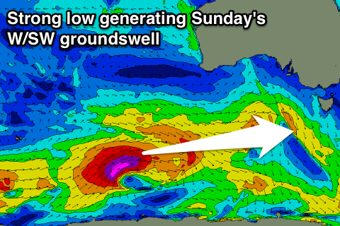
The stronger and better W/SW groundswell for Sunday is still on track, with a vigorous polar low forecast to develop south-west of WA this evening, aiming a fetch of severe-gale to storm-force W/SW winds through our western swell window.
This will be a long-period and strong swell, building through Sunday to a good 2-3ft. Winds are looking favourable with a W/NW offshore most of the day, more N/NW Monday as the swell eases back from 2ft.
Now, looking into the middle of next week, a vigorous polar frontal progression will develop south-west of WA again over the weekend, moving east towards us early next week.
An initial pre-frontal fetch of gale to severe-gale W/NW winds will generate a moderate sized W/SW swell for late Tuesday, with a stronger increase Wednesday from post-frontal severe-gale to storm-force W/SW winds.
We'll have a closer look at the sizes and timings on Friday but for now conditions are looking great with offshore winds. Tune in next update for the latest.

