Good swell mid-week, small fun waves after
Southern Tasmania Surf Forecast by Craig Brokensha (issued Monday 20th March)
Best Days: Thursday morning, Friday morning, Saturday morning, Sunday morning
Recap
A little more size then expected Saturday morning which was a nice surprise, tiny into Sunday and similar today with onshore winds.
This week and weekend (Mar 21 - 26)
Tiny average surf is expected tomorrow again with winds from the eastern quadrant, but our new SW groundswell for Wednesday afternoon and Thursday morning is still on track.
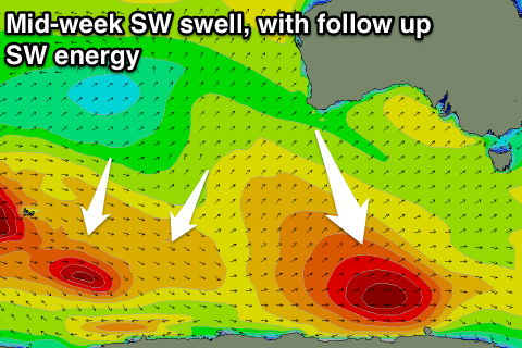
 A strong polar low in our far swell window generated a fetch of severe-gale to storm-force W'ly winds. The low is now weaker, pushing along the polar shelf while continuing to generate W'ly gales.
This should extend the longevity of the swell, with an increase to 2ft+ Wednesday afternoon, easing from 2ft to possibly 3ft early Thursday.
Unfortunately moderate to fresh SE winds will create average conditions Wednesday, lighter Thursday and hopefully variable through the morning (we'll review this Wednesday).
Small SW swell energy to 1-2ft should ebb and pulse from Friday through Sunday from a couple of pre-frontal W/NW fetches moving through our swell window from south-west of WA, along the polar shelf.
Better offshore winds are expected each morning, creating good conditions.
Longer term we're expected to see a strong node of the Long Wave Trough moving in from the west early next week, and with this a vigorous mid-latitude frontal progression is forecast to fire up in our western swell window.
Some solid W/SW groundswell is on the cards, but we'll check this Wednesday.

