Small infrequent swell mid-week
Southern Tasmania Surf Forecast by Craig Brokensha (issued Monday 13th March)
Best Days: Exposed breaks later tomorrow and Wednesday morning
Recap
Tiny waves all weekend with favourable conditions, continuing into this morning.
This week and weekend (Mar 14 - 19)
Tomorrow morning is expected to start out tiny, but our new SW groundswell due into the afternoon and Wednesday morning is still on track.
This swell was generated late last week and over the weekend by a strong but distant polar low.
We should see the swell kick to an inconsistent 2ft on the sets later tomorrow, easing from a similar size Wednesday morning, tiny Thursday.
Conditions will be best at exposed breaks tomorrow with an N/NW tending fresh N/NE breeze into the afternoon and then gusty N'ly winds Wednesday.
 Into the end of the week, a front pushing across us on Thursday/Friday will generate a quick burst of strong W/SW winds through our western swell window.
This might generate 1ft+ of W/SW swell through Friday afternoon with variable tending E/NE winds.
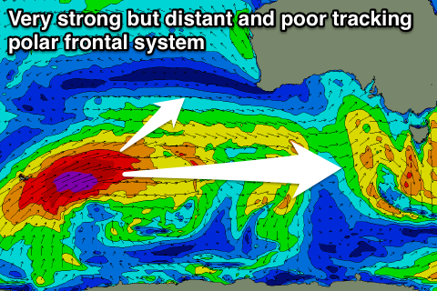
Beyond this we have a really tricky and inconsistent W/SW groundswell source for later Sunday and Monday morning.
A very strong and powerful low is currently deepening south-east of South Africa and this will travel along the polar shelf over the coming days, generating winds in the severe-gale to storm-force range on the edge of our swell window.
The models are showing a bit of size hitting the West Coast, but I'm concerned about the distant and track of the system for the South Arm. We may see 1-2ft sets if we're lucky later Sunday and more so Monday morning but with average E'ly winds. We'll have a closer look at this Wednesday though.

