Good S/SE swell then W/SW swell for the weekend
Southern Tasmania Surf Forecast by Craig Brokensha (issued Monday 20th February)
Best Days: Wednesday morning, Sunday morning
Recap
A good weekend of swell and winds if you could find a bank. Two separate pulses of W/SW groundswell to 2-3ft Saturday and Sunday, easing back from 1-1.5ft this morning with an onshore wind.
This week and weekend (Feb 21 – 26)
 A surface trough responsible for today's onshore change has now formed into a low to our south-southeast, and a fetch of strong S/SE winds will be generated in our southern swell window (right) this afternoon and evening swinging more W/SW through tomorrow afternoon and out of our swell window.
With this we'll see a good sized S/SE swell all day tomorrow to 2-3ft across Clifton, easing back from a similar size Wednesday morning, tiny into Thursday.
Winds tomorrow unfortunately look dicey for Clifton with a W/SW tending S'ly breeze, but Wednesday looks better with a N/NE tending E/NE breeze.
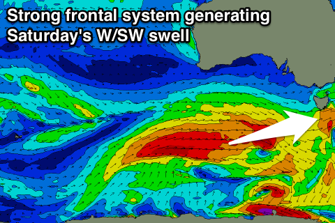
As discussed last update, some new W/SW groundswell is due to build through the end of the week, produced by a strong polar frontal progression firing up south-west of WA this evening and pushing east through our western swell window all week.
An initial front will produce a fetch of strong to gale-force W/SW winds through our western swell window, generating an initial pulse of W/SW groundswell building Friday afternoon, while a secondary stronger and closer fetch of W/SW gales will produce a better swell for Saturday.
 We should see Clifton building to 1-2ft later Friday, with Saturday's swell reaching 2-3ft through the day. The easing trend should be slow owing to a good fetch of polar W/SW winds on the tail of the progression along the polar shelf.
This should see Clifton easing from 2ft+ Sunday morning. Winds on Friday afternoon will be onshore with sea breezes, while Saturday an onshore SW change with the swell producing front is due around dawn. Sunday looks best with an offshore tending variable breeze.
Longer term a small spike in W/SW swell may be seen Tuesday morning with favourable winds, with small W/SW swells from later next week.

