Fun W/SW swell over the weekend
Southern Tasmania Surf Forecast by Craig Brokensha (issued Friday 17th February)
Best Days: Saturday, Sunday, Tuesday morning
Recap
Tiny waves to kick off yesterday morning ahead of a strong kick in W/SW groundswell through the afternoon.
This swell has eased off quicker than expected this morning though with fading 1-1.5ft sets on the beaches.
This weekend and next week (Feb 18 – 24)
This weekend we've got some good W/SW groundswell due across the South Arm along with favourable winds.
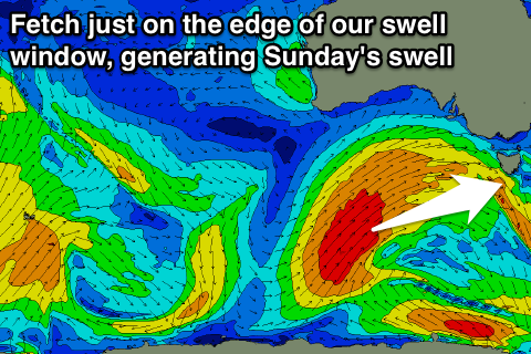
 A vigorous frontal system that's been pushing up towards the Great Australian Bight, just on the edge of our swell window. The front is now pushing slowly east while continuing to sit just in our swell window, and this will help keep the surf up into Sunday.
With the fetches being just within our swell window, the direction of the swell will be quite west, but an increase to 2-3ft is expected at exposed breaks through the day Saturday, easing from a similar size Sunday morning.
Winds over the coming weekend are looking generally favourable as the front stalls to our west, directing NW tending variable winds across us tomorrow and N/NW tending E/NE winds Sunday.
Monday looks to be smaller and easing from 1-2ft along with poor S/SW tending S/SE winds as a surface trough/developing low moves across us.
Some small weak S/SE windswell is due off this low Monday afternoon, with lingering 1-2ft sets Tuesday and early Wednesday as a weak fetch of S/SE winds remain to our south-east Monday evening.
Conditions will improve again into Tuesday with a morning offshore, similar Wednesday.
Longer term a good run of W/SW groundswell is expected from later next week as a series of strong polar fronts fire up through our western swell window again.
With the westerly track we're probably only looking at sets to 2-3ft at the swells peak, but more on this Monday. Have a great weekend!

