Solid spike in swell tomorrow afternoon, fun swell for the weekend
Southern Tasmania Surf Forecast by Craig Brokensha (issued Wednesday 15th February)
Best Days: Thursday, Friday, Saturday, early Sunday, Monday morning
Recap
Good fun 2ft waves yesterday morning with a mix of easing W/SW swell and building S/SW swell. Today the S/SW swell was easing back from a clean 1-2ft.
This week and weekend (Feb 16 – 19)
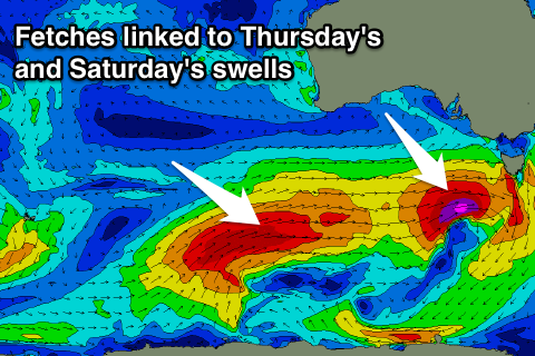
Looking at tomorrow afternoon's strong kick in W/SW groundswell and the track of the intense low to our west-southwest looks a little more west than forecast Monday.
With this we're probably only expected to see the swell reaching 3ft through tomorrow afternoon, easing back from 2ft+ Friday morning.
 Conditions should be clean early with a N/NW offshore, before sea breezes from the east kick in, while Friday will see all day offshore NW winds.
The tricky W/SW swells for the weekend are still on track with a great fetch of severe-gale W/SW winds on the polar shelf in our far swell window expected to project north-east towards the Bight away from our swell window.
We'll still see winds generated long enough in our swell window to generate some decent W/SW groundswell, with the swell expected to fill in Saturday and build to 2-3ft at magnets through the day.
The reinforcing swell for Sunday I'm a little wary of, with the fetch just falling in our swell window. Waves should hang around 2ft, but maybe no more.
Winds on Saturday will be good all day and from the NW, with an early W/NW breeze Sunday, tending W/SW through the day.
Longer term easing surf is expected into early next week, with a couple of sources of surf for later in the week. That being a mid-latitude frontal progression and a possible low forming south-east of us. More on this Friday.


Comments
Satellite observations are good for today's kick.