Tiny surf most of the week, a touch bigger mid-week
Southern Tasmania Surf Forecast by Craig Brokensha (issued Monday 23rd January)
Sign up to Swellnet’s newsletter and receive the South Arm Forecaster Notes and latest news sent directly to your inbox. Upon signup you'll also enter the draw to win a surf trip to P-Pass for you and a mate (this is the last week to enter). It doesn’t get much easier so click HERE to sign up now.
Best Days: Wednesday morning, Sunday morning
Recap
A small SE groundswell to an inconsistent but fun 1-2ft on Saturday and Sunday, fading back today to the 1ft+ range.
This week and weekend (Jan 24 - 29)
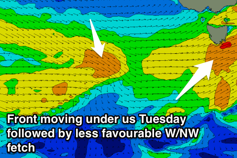
Besides on final pulse of SE groundswell tomorrow afternoon through Thursday (1ft max) we should see some small W/SW swell building through tomorrow afternoon, easing off into Wednesday.
The size of this swell has been upgraded a touch with a strengthening front due to produce a broad fetch of strong W/SW winds below us, followed by a less favourable W/NW aligned front Wednesday.
 An afternoon kick to 1-2ft is due but with strong W/SW winds, easing from a similar size early Wednesday with offshore winds.
Persistent but weak and less than favourably aligned mid-latitude frontal activity should keep 1ft+ surf hitting Clifton through the rest of the week, with some better size for the weekend.
The weekend's swell will be produced by a slightly stronger mid-latitude front moving in and under us Saturday afternoon, aiming a fetch of strong W/SW winds through our western swell window again.
This swell looks to only reach 1-2ft through Sunday with morning offshores, easing into Monday.
Longer term besides another small W/SW groundswell Tuesday there's nothing too major on the cards unfortunately.

