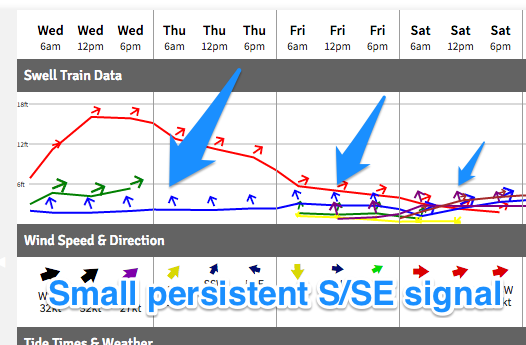
Small persistent SE swell
Southern Tasmania Surf Forecast by Craig Brokensha (issued Wednesday 18th January)
Sign up to Swellnet’s newsletter and receive the South Arm Forecaster Notes and latest news sent directly to your inbox. Upon signup you'll also enter the draw to win a surf trip to P-Pass for you and a mate (there's only 2 weeks left). It doesn’t get much easier so click HERE to sign up now.
Best Days: Every morning over the period at spots open to SE swell
Recap
Fun clean levels of S'ly swell continuing at 2ft yesterday, while today a mix of S/SE and new W/SW swell are coming in at a similar 2ft across the South Arm.
This week and weekend (Jan 19 - 22)
The coming forecast period is a little flukey.
 Today's increase in W/SW swell is expected to ease back from 2ft tomorrow morning out of a more SW direction, while some small inconsistent SE groundswell from a persistent fetch of polar SE winds through our swell window is due.
The fetch is expected to weaken a little into the end of the week before broadening and strengthening again Friday evening and through Saturday.
This should see small levels of SE swell persisting tomorrow through the weekend at an inconsistent 1-2ft, easing off Monday.
A final pulse of swell is then due Tuesday and Wednesday to possibly 1-2ft, easing Thursday.
Winds through this period should be at least variable and mostly offshore each morning ahead of sea breezes of shallow changes.
Through Tuesday next week a strong front passing across us should kick up a small increase in W/SW swell through the afternoon, to 2ft max, easing back Wednesday.
Longer term we may see some small W/SW swell later next week/weekend, but more on this Friday.

